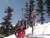
| Skiing in Taos, February 2006 | ||||
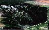
Google Earth image of the Taos Ski Village and of the ski area. The city of Taos is in the upper right corner. |
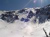
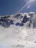
This was a dry winter in New Mexico and the snow was not anything specia, |

|
|

|
|

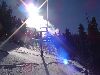
My favorite Bavarian pub in the back bowl |
|
|

Proper means of re-hydration ... |

... and nourishment ... |
... followed by relaxation. |

|
|
|
|

|
|
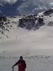
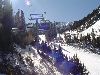
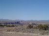
Most of south facing slopes had no snow |
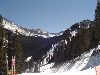
Ridges usually brimming with snowdrifts were also dry |
Only north cafing slopes had skiable snow |
Only north cafing slopes had skiable snow |
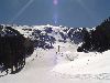
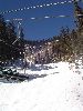
Last view of the Taos ski bowl for this winter. The time is 12 noon. |
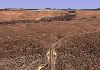
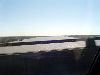
View of Rio Grande Gorge from highway 68 between Taos and Santa Fe. The time is 2 pm, 1200 miles (2000 km) to go. |
Corresponding 3D rendering of the Rio Grande Gorge from Google Earth. |
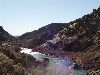
Rio Grande between Taos to Santa Fe. Fans of Czech "cundr" (tramping) will recall Waldemar Matuska's 1965 hit song "The Yellow Rose of Texas" (Zluta ruze z Texasu) |
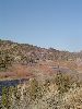
More of Rio Grande. The time is 2:30 pm. |
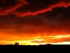
Sunset between Santa Fe and Albuquerque. The time is about 7 pm. |

... and sunrise ofver Houston! The time is about 7 am, 360 miles to go. |

Welcome sign on I-10 bearing signs of torture by Hurricane Rita. The time is 10 am. |

Atchafalaya RIver causeway between Baton Rouge and Lafayette. The time is 11 am. |
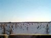
Henderson Swamp in the Atchafalaya River Basin. The time is 11:30 am. |
Mississippi River photographed from the Wilkinson Bridge(I-10) in Baton Rouge. another hour to go. |
||
BACK to our family page
Copyright © 2006 by Radim A. Kolarsky
All rights reserved