|
The Story Of Sparkling Water And Plate Tectonics
Mineral Water On Your Table - Food-And-Water Pairing
Good mineral water is a delicacy, almost like wine. Selecting the right water is as important
as selecting the right wine to maximize the enjoyment of dining. The choice of water
seamlessly complements the food as well as the wine. This is because no two mineral
waters are the same.
Sparkling and still mineral waters. |
Colloquially, the term "mineral water" is often used to mean any bottled water, as
opposed to tap water, but this is completely incorrect. Mineral water is groundwater,
which contains high amounts of dissolved material called Total Dissolved Solids (TDS).
Different countries have different rules for classifying mineral waters, but they all
revolve around a certain minimum amount of TDS. TDS is a broader parameter than water hardness,
which only considers calcium and magnesium. Mineral salts containing calcium and magnesium,
collectively known as carbonates, are the most common minerals dissolved in groundwater.
They are obtained from the chemical dissolution of carbonate rocks such as limestone
and dolomite. Carbonate rocks dissolve in water very readily and such water
is characterized by the presence of the bicarbonate ion, HCO3. The typical
carbonate minerals that dissolve in groundwater are calcite (calcium carbonate CaCO3,
the chief constituent of limestone), dolomite (calcium-magnesium carbonate
CaMg(CO3)2, the chief constituent of the sedimentary rock of the same name),
and siderite (iron(II) carbonate FeCO3). Beside carbonates, other compounds
dissolved in mineral water can include sodium (Na+), potassium (K+),
calcium (Ca2+), magnesium (Mg2+), chlorides (Cl-),
nitrates (NO3-), sulphates (SO42-), etc,
all disolved as ions. For example, Evian contains 360 mg/liter bicarbonate, 80 mg/liter calcium,
26 mg/liter magnesium, 15 mg/liter silica, 12.6 mg/liter sulphates, followed by small amounts
of sodium, potassium, and chlorides.
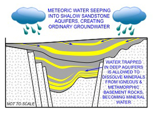
Cross section showing a typical mineral-water aquifer. |
Meteoric water enters an aquifer in a recharge zone, where the aquifer outcrops at the surface.
The water seeps through pores and fractures in the rock, dissolving various minerals,
and can either come back to the surface as a spring or become trapped in the aquifer underground.
Mineral waters typically stay underground for several decades. For example, San Pellegrino
water spends about 30 years underground during its journey from the aquifer recharge zone
in the Italian Dolomites to the spring in San Pellegrino Terme in Lombardy.
During that trip, the water is mineralized and becomes enriched with 14 mineral salts
including calcium and magnesium, and is heated by geothermal heat to come back to the surface
at 22.6° Celsius (73 degrees Fahrenheit).
An aquifer, which is typically sandstone or limestone but can also be fractured igneous rock,
contains pores and/or fractures that create permeability, which allows the water to seep
through. As that happens, given enough time, groundwater dissolves certain minerals in the
aquifer rock, and perhaps also in the rocks that seal the aquifer above and below, and absorbs
them. Ordinary roundwater becomes mineral water. If the aquifer becomes
buried by younger sediments, the whole system can remain sealed for long periods of geologic time.
In fact, this is how many oil and gas fields of the world work: hydrocarbons and fossil formation
water being trapped and sealed in the system for possibly tens of millions of years. However,
fossil formation waters tend to be very saline, too much to be palatable. Mineral waters
are not very different in principle, just stay underground for a shorter period of time and
and absorb less TDS.
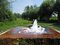
Nuskova mineral water spring in the Prekmurje
region of northeastern
Slovenia. Water color is due
to high content of dissolved minerals. |
It is obvious that the longer groundwater stays trapped in the system, the more opportunity
it has to absorb minerals. It is also obvious that not every spring water by far can be
called mineral water. Various bottled waters sporting images of mountains and glaciers,
and names sich as "pure spring water", "glacier water" or "pure mountain water" can be
simple groundwater or even purified tap water derived from the local river.
At the dining table, for water to be called "mineral water" it needs to have pretty much
the same composition as when it came out of the ground. No minerals may be added to it;
permitter is only the re-introduction carbon dioxide (CO2); no disinfection
treatment is permitted, nor is the addition of any bacteriostatic agents. This means that
the water that lands on your table is as close as possible to water in the aquifer in the ground.
On the U.S. market, mineral water needs to contain at least 250 parts per million TDS
and originate from a geologically and physically protected underground water source.
In the EU, the rule is that it has to be bottled at the source and undergo no or minimal
treatment. Permitted is the removal of iron, manganese, sulfur and arsenic.

Baden-Baden in southwestern Germany. |
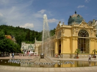
Mariánské Lázně (Marienbad) in western
Czech Republic. |
Healing qualities have long been attributed to mineral water. Curative properties have been
attributed to various mineral waters ever since the Roman Empire. Julius Caesar had a spa
built around the naturally carbonated springs of Vichy in central France, and to this day
balneologists recommend drinking Vichy water, notable for its sodium bicarbonate content,
as a digestif. Mineral waters became the foundation for the European spa industry since
the Middle Ages. While the general ideas behind balneotherapy are definitely justified,
some of the healing effects of spa treatments are more for the mind than for the body. People get away from
the daily grind, away from the boss or from screaming kiddies, enjoy a relaxing bath,
Karlovy Vary (Karlsbad) in western Czech Republic. |
some nice dinners and drinks, perhaps a stop at the casino ... The life.
It is also important to keep in mind that by drinking mineral water, we often drink brine
(fossil formation water) that has been in the ground for a while and picked up many things.
Badoit, for instance, contains about 11 times the amount of salt compared to typical tap water.
San Pellegrino contains double the amount, and Perrier on the other hand, about half the
amount. So, if maintaining proper blood pressure is of importance,
mineral waters need to be chosen wisely.
Beside TDS, mineral water is also characterized by its acidity (pH). A solution
is said to be acidic when its pH is 0-7, neutral at pH 7, and basic (alkaline) at pH 7-14.
Acidic waters can taste sour; slightly basic waters (pH 7 and slightly higher) taste sweet;
and highly alkaline waters (pH significantly higher than 7, close to 14), can taste bitter
and have a slippery feel.
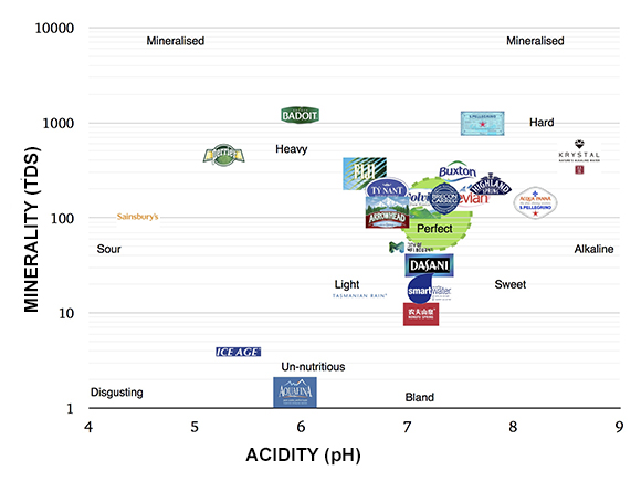
Mineral water composition by brand. (Figure adopted from James Kennedy,
Chemistry professor, Haileybury Academy, Melbourne, Australia.) |
Popular mineral waters such as Perrier, Badoit and San Pellegrino have high levels of
mineralization and span the acidity spectrum from slightly acidic (Perrier) to slightly
alkaline (San Pellegrino). Most mass-marketed water, however, cluster around pH 7
(neutral) and moderate mineralization levels. Waters with low levels of mineralization
(low TDS) tend to taste bland, approaching tap water. If such water has a low pH (acidic),
it will tend to simply taste disgusting.
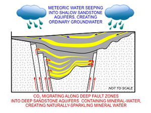
Cross section of a rift basin bound by deep extensional faults,
showing mineral-water aquifers
absorbing CO2 charge. |
The third significant parameter of mineral water is its carbonation: the concentration of
CO2 naturally dissolved in the water when it is collected. Based on this, mineral
waters can be divided into:
- Still - no carbonation (Evian)
- Lightly carbonated - nearly still with some bubbles (Badoit)
- Bold - big bubbles with big pops (i.e Perrier).
CO2 gas dissolved in water at a low concentration (0.2–1.0%) creates carbonic acid
(H2CO3).
All of the above combines when the subject of pairing water and food comes up.
Mineral water has stepped into the pairing arena, and water-and-food pairing is now an acquired
taste, just like wine. However, unlike wine, pairing water with food depends largely on the
overall mouthfeel of the water, and flavor second. The mouthfeel of mineral water is determined
by its carbonation level. For example, a boldly carbonated water can overwhelm subtle dishes,
but may go well with crispy food. A boldly carbonated water will do well as a starter drink,
much like champagne. A finely carbonated water may be more suitable for salads or grilled
seafood salad, A still water may be well suited for a light first course, and a lightly
carbonated water for a second course.
The next level of food-and-water pairing is matching the food with the mineral content of
the water. A water with highly mineral content has weight to it and can be paired with big
flavors like grilled beef, lamb, and hard cheeses.
The final level of food-and-water pairing lies in the acidity. Waters that are slightly
alkaline (basic) can taste sweet, while highly alkaline water can taste slightly bitter
(i.e. San Pellegrino). Slightly alkaline waters can go well with desert. Highly alkaline
waters can be used in place of a digestif after-dinner drink. Slightly acidic waters
go with fatty food or seafood.

Naturally-Carbonated Mineral Water - where does it come from?
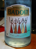
Badoit eau minérale naturelle gazeuse. |
In this essay, we are focusing on naturally-carbonated mineral waters, and give a throught
to how and where they originate. In the world of mass-produced fizz drinks, the question is
often asked whether naturally-carbonated waters actually exist? You bet they do! Granted,
some bottled mineral waters are artificially carbonated but naturally-carbonated mineral waters
do exist. The big question that obviously begs itself is: How do they form? How does
CO2, an evil gas we are being told to despise because it causes global warming,
get in mass amounts into groundwater?
The simple answer is: magma.
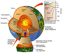
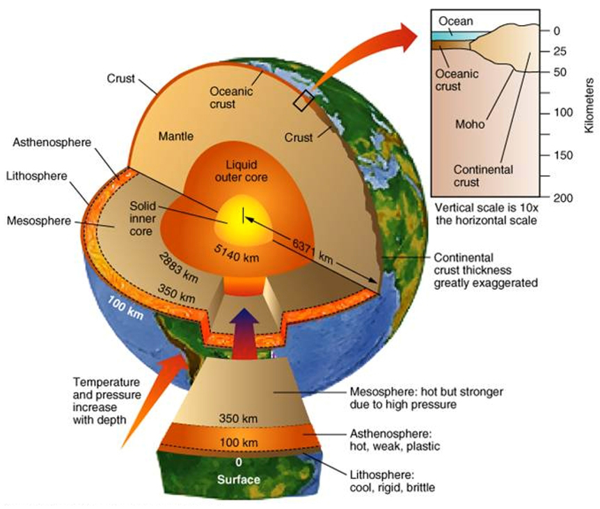
Cross section of the Earth (Click for a larger image). |
It helps to digress a little into geology. The Earth is like an avocado: formed by
a thin rigid skin called the Lithosphere, underlain by a thicker soft layer called
the Astenosphere that is a semi-molten state (not quite a liquid magma but not a solid
rock either), below which lie the Mesosphere and the Core. The Lithosphere, the outer shell
of the Earth, is made up of tectonic plates that float and slide on the semi-molten
Astenosphere. And it is the Asthenospere that is the source of CO2 that
is found in some mineral waters. What determines which mineral water will be
naturally-carbonated and which one will be still are migration pathways through
the Lithosphere that the CO2 can migrate along, enter an aquifer
near the surface containing mineral water, and mix with it.
Such migration conduits are usually very deep fault zones that reach from the surface
all the way to the bottom of the Lithosphere. Such fault zones can be either extremely
deep rift zones i.e. the European Cenozoic Rift System (ECRIS), or subduction zones i.e.
the ones below the Alps and the Carpathians, below the Pyrenees, the Appenines,
the Dinarides, or the Caucasus. These planetary-scale scars form when continents
collide or break apart.
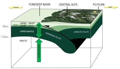
Subduction zone beneath the Alps, acting as a conduit for CO2 migration. |
The Tertiary subduction zones were formed by mountain-building processes that have been
happening in southern Europe over the past 65 million years. These have, in turn, been
related to the continental collision between the European Plate and the various microplates
pushed northward in front of the advancing African Plate. These subduction zones represent
what is left of the floor of an ancient ocean, called the Tethys Ocean, that had been
largely consumed in these
Grabens belonging to the European Cenozoic Rift System (ECRIS). |
subduction zones. In the final stages of the collision, as the Africa-derived
microplates were thrust over the edge of the European Plate, the European Plate cracked
in several places, creating the European Cenozoic Rift System.
CO2 from the Earth's mantle, specifically the Aestenosphere, takes advantage
of these deep-seated fault zones and migrates up to the Earth's surface.
If the migrating CO2 reaches mineral-water aquifers in the upper crust,
it mixes with it, creating naturally-carbonated mineral water.
Looking at the sources of naturally-carbonated mineral waters over the European continent,
their distribution may seem completely random at first glance. Several of the most
famous ones are found in Southern Europe in the south of France and in Italy (Perrier,
San Pellegrino etc.). Some are found in Central Europe (Apollinaris, Gerolsteiner, Mattoni,
Römerquelle etc.). Others are found in Eastern Europe in Bulgaria, Romania and Slovakia
(Sulinka, Borsec). More are found in northern Spain and southwestern France along the Pyrenees.
To the east, in Georgia, a good example of a good sparkling mineral water is Borjomi.
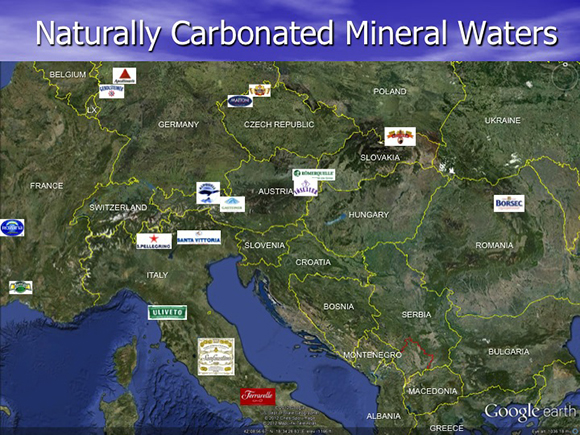
Distribution of naturally-carbonated mineral waters across Europe.
Random or systematic?cv |
But why do they occur where they occur? Why are naturally-carbonated mineral waters like
Mattoni or Perrier, for instance, not found in the middle of Poland? There is indeed a pattern
to their occurrence. There is an underlying principle that controls the distribution of natural
sparkling-water springs - and that principle is Plate Tectonics.
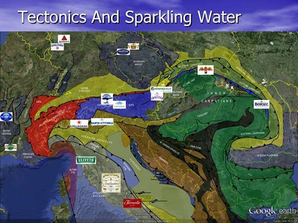
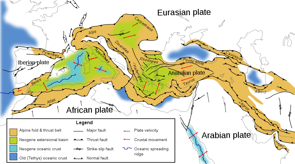
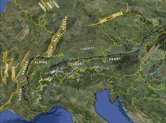
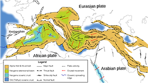
Sources of naturally-carbonated mineral waters superimposed on a simplified
tectonic map of Europe. They are clearly tied to the tectonic systems that were formed during
the last 65 million years (the Tertiary Period): the Alps-Carpathians, the Apennines, Dinarides
and Pyrenees, plus the European Tertiary Rift System. |
The reason is quite simple, at least in general. Sources of naturally-carbonated mineral waters
in Europe are tied to the fold-and-thrust belts and rift zones that formed during the last 65
million years (the Tertiary Period), during the closure of the Tethys Ocean. All of these zones
are associated with deep-seated faults that allow the migration of CO2 from the mantle
(Asthenosphere) to near the surface, where it mixes with mineral water, creating naturally-carbonated
mineral water. Perrier lies in the Rhône Graben; Rozana lies in the Limagne Graben, just south
of the town of Vichy; Gerolsteiner and Apollinaris lie in the Lower Rhine Graben; Mattoni and Korunní
lie in the Eger Graben; Alpquell, Gasteiner, Römerquelle, Vöslauer, Sulinka, and Borsec lie along
the leading edge of the Alpine and Carpathian thrust front; Uliveto, Sanfaustino and Ferrarelle
lie along the Appenine thrust front. These springs are very obviously tied to tectonic lineaments
that allow the migration of CO2 to the surface.
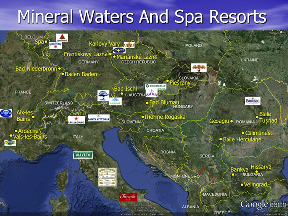
When major spa towns are added (where both natural-carbonated and still mineral springs
are found), the picture becomes ever more clear. These springs are clearly tied to the
Tertiary tectonic systems. |
The general relationship between mineral waters and Tertiary tectonics is even more apparent
when spa towns are added into the picture (not all of which are producing sparking mineral waters).
They are all located within the European Cenozoic Rift System (ECRIS), or the mountain belts of
the Alps, Carpathians, Pyrenees, Apennines, Dinarides, and the Caucasus. Vichy lies in the
Limagne Graben; Aix-les-Bains, Ardèche and Vals-les-Bains lie along the Rhône Graben;
Bad Niederbronn and Baden-Baden lie along the Upper Rhine Graben; the Belgian town of Spa
(of Formula 1 fame) lies along the Lower Rhine Graben; Františkovy Lázně, Mariánské Lázně
and Karlovy vary lie along the Eger Graben; Bad Ischl, Piešťany, Băile Tușnad, Călimănești,
Băile Herculane, Bankya, and Hissarya lie along the leading edge of the Apline-Carpathian
thrust front. Againm, it is not accident that thermal springs occur along these tectonic
lines.
Europe present-day. |
The topographic map of southern Europe is dominated by a series of mountain belts.
These include the Pyrenees, Alps, Carpathians, Apennines, Dinarides and Caucasus mountains.
These are gigantic fold-and-thrust belts, formed by compressional forces that have caused
blocks of rock material to deform into large folds, separate into tectonic units
and thrust on top of each other like snow piling up in front of a bulldozer blade.
Tertiary tectonic map of Europe.
(Click to see a larger figure.) |
From west to east, there is a number of distinct mountain belts that formed during the
Tertiary Period: the Pyrenees separating Spain from southern France, the Atlas, Rif and Betics
units in Spain and north Africa, the Alps and Carpathians in Central Europe, the Apennines
forming Italy, the Dinarides and Hellenides forming the Balkans and Greece, the Caucasus
Mountains forming Georgia and Azerbaijan, and the Taurus and Zagros Mountains forming Turkey
and Iran.
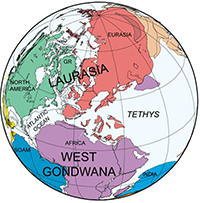
The Tethys Ocean 150 million years ago (Mesozoic Era). |
Where these mountains stretch across the continent today, there was once a vast ocean called
the Tethys, as large as the Atlantic Ocean is today. These mountain belts is what is left
of it. The Tethys formed some 250 million years at the end of the Paleozoic Era, during
the final assembly of the supercontinent Pangaea when all of the present-day continents
collided together. Pangaea was shaped like the letter C. The Tethys Ocean
separated present-day Central Europe on the northern part of the C (Laurasia) from
present-day Africa, India and Australia on the southern coast (Gondwana).
The Tethys had been in existence well over 200 million years until the Miocene (some 15
million years ago). It began to shrink during the Tertiary (65 million years ago),
as the Atlantic Ocean began to open. The Tethys came to a close as the tectonic forces acting
between Africa and Europe caused it to partially subduct underneath the present-day European
continent, and partially thrust over it. Sedimentary rocks previously deposited in the ocean
basin (sandstones, shales, limestones, salt etc), along with igneous and metamorphic rocks
that had formed the basement, were compressed, folded and thrusted in gigantic sheets on
top of each other over the southern edge of the European Plate, forming the Pyrenees, Alps,
Carpathians, Dinarides, Appenines, anbd Caucasus in places where the ocean had previously
existed. The rocks found today on the surface, and the deep fault zones separating these
thrust sheets are all that remains from a once mighty ocean.
The European Cenozoic Rift System (ECRIS). |
As the Alps were being loaded onto the European Plate, the plate rebounded and cracked in
several places. The result is the European Cenozoic Rift System (ECRIS). This is a system
of narrow, linear sedimentary basins bounded by deep fault systems. The Rhône Graben in
eastern France, the Rhine Graben in Southern Germany, the Eger Graben in the Czech Republic
and the Lower Rhine Graben in Belgium and Holland are all part of it. Relatively recent volcanic
activity is associated with the Eger Graben (the volcanoes of České středohoří and
the supervolcano of Doupovské hory). Moderate seismic activity is associated with
all branches of the ECRIS. Naturally-carbonated mineral waters are also found in all branches
of the ECRIS. The rift basins are bound by extremely deep faults that reach from the surface
deep into the Lithosphere, and act as conduits for magma and CO2 to come up to the surface.
These fault zones, like giant scars, reach all the way to the Asthenosphere. As has been explained,
the Asthenosphere consists of partially molten rock material, and molten rock is always a source
of carbon dioxide (CO2). These deep fault zones have been acting as migration conduits for
CO2 to travel to near the surface. There, it is mixes with existing mineral water
to form naturally-carbonated mineral water.
The story starts to dawn that naturally-carbonated mineral waters, such as Perrier,
San Faustino, San Pellegrino, Badoit, Römerquelle, Mattoni or Gerolsteiner, are tied to
the fold-and-thrust belts created during the closure of the Tethys Ocean, and to the rift
systems that formed in the European Plate where it cracked as the Alps were being loaded onto it.
When a bottle of Vichy or Mattoni lands on your table next time, think of it as the last
vestiges of the Alpine Orogeny and of the once mighty Tethys Ocean!
A 15-Minute Primer In Plate Tectonics:
Cross section of the Earth (Click for a larger image). |
The Earth has a radius of about 6,371 kilometers (3,959 miles). In a cross section, it looks
rather like a big avocado, composed of a rigid, thin outer shell called the Lithosphere,
underlain by a ductile, semi-molten layer called the Asthenosphere, which in turn sits on
top of the Mesosphere that surrounds the Core. The Lithosphere is about 100 km thick
(i.e. in the Eastern U.S.), and the Asthenosphere another 250 km. (Surviving from older
terminology, the terms Crust and Mantle continue to be used.)
Tectonic plates forming Earth's Lithosphere.
(Click to see a larger figure.) |
The Lithosphere is divided into tectonic plates, rigid slabs of rock that float on top of
the Asthenosphere, driven by convection currents within the Asthenosphere produced by
heat generated in the Core. A plate can consist of continental material (basement consisting
of granite and metamorphic rocks related to granite, usually blanketed by a sedimentary cover).
Or, it can consist of oceanic material (basalt, covered with sediments). Some lates are composed
entirely of oceanic material, such as the Pacific, Nazca, Cocos or Caribbean Plates. That
portions of these plates stick above sea level and form island or the Central American isthmus
does not make them continents. They are simply parts of oceanic crust sticking above sea level.
Most plates, however, are composed of both continental and oceanic material. For instance, the North
American Plate consists of North American continent, to which oceanic crust is acreeted
in the Arctic and and Atlantic Oceans. It is interesting to note that the western half of Island
is part of the North American Plate, but for instance Point Reyes in California is not because
it lies west of the San Andreas fault the western boundary of the North American plate).
Divergent, convergent, and strke-slip plate boundaries. |
The plates composing the Lithosphere move, driven my convective currents in the underlying
Asthenosphere, which in turn are driven by heat generated by the Core. As the plates move,
they interact with each other along their edges. The Pacific Plate moves NW along the
San Adreas Fault in Mexico and California, relative to the North American plate. On its
eastern end, the North American plate is moving away from the Euasian Plate, accommodated
by the spreading of the Atlantic Ocean. Along the western coast of South America, the
Nazca Plate is subducting underneat the South American Plate. Based on these types of
relative motion, three basic types of plate boundaries: transform, divergent and convergent.
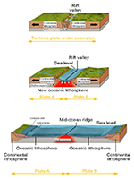
Divergent plate boundary.
(Click to see a larger figure.) |
A divergent plate boundary forms when a continent is exposed to extensional forces coming
from the deeper asthenosphere, a rift valley forms and the continent cracks in two. This is
currently happening along the East African Rift where the eastern part of the continent
is being broken away from the rest of the African Plate. A rift valley is topographically low,
which means it will be filled with water, first in the form of lakes and later sea.
As rifting proceeds, magma from the Asthenosphere exploits the zone of weakness in the plate
above, and once the continents separate, it starts filling the space between them. Magma
rises to the surface, acreets to the edges of each of the two new plates, and as they continue
to drift apart, more and more new lava fills the space in the middle. A mid-ocean ridge
is formed and a new ocean is born.
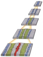
Seafloor magnetic anomalies. |
Mid-ocean ridges are present in all of the Earth's oceans, and are the sources of new oceanic
crust that is being formed and added to existing older oceanic crust on each side of the ridge.
As seafloor spreading continues at the ridge, and oceanic crust moves like a conveyor belt
away from the ridge, linear magnetic anomalies are formed on the seafloor every time the Earth's
magnetic field flips it polarity every few million years.
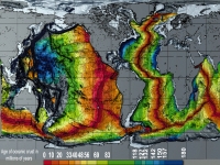
Age of oceanic crust (source: NOAA)
Click to enlarge. |
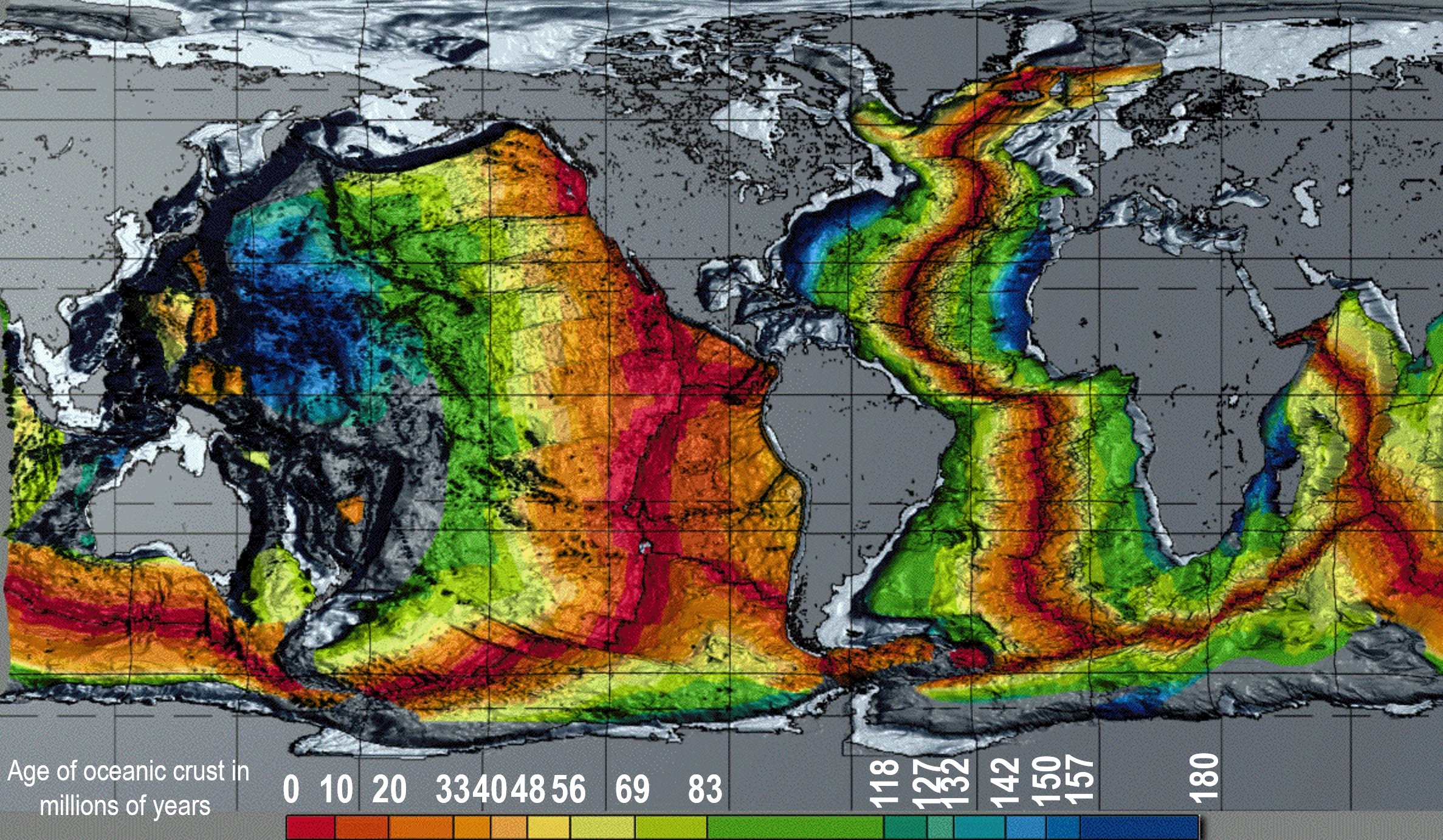
It is there seafloor magnetic anomalies that are one of the pillars of modern plate tectonics,
and the principal mechanism that enables reconstructions of plate motions throughout geologic
history. The figure on the right show the age of oceanic crust of millions of years. The oldest
oceanic crust is found in the Western Pacific where it is actively being consumed underneath Japan,
and on both sides of the North Atlantic. In the Atlantic, the old crust is firmly attached to the
North American and African continents, whith which it forms two respective tectonic plates,
each of which is composed of continental crust and oceanic crust. The youngest oceanic crust
is naturally present at all of the mid-ocean ridges.
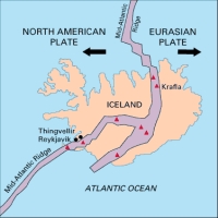
The Mid-Atlantic Ridge exposed on Island. |
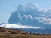
Eyjafjallajokull volcano plume 2010
(from Wikimedia Commons). |
Mid-Ocean Ridges are zones of intense volcanism. They are chains of volcanic mountains
thousands of meters high, hidden mostly below sea level. On Iceland the Mid-Atlantic Ridge
can be seen and touched because it happens to rise above sea level to form the island.
Depending on the geometry of a plate boundary, that boundary can change laterally from
a divergent to a transform one, to a convergent one. The Pacific Plate, for example,
forms a divergent plate boundary along its southeastern edge with the Antarctic and Nazca Plates,
forming a Mid-Ocean Ridge called the East Pacific Rise. However, from Baja california northward
along the coast of California, where the Pacific Plate meets the North American Plate, the
plate boundary becomes a transform one, because of the orientation and relative motion
vectors of the two plates.
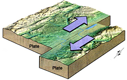
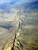
Transform plate boundary. (Click to see a larger figure.) |
San Andreas Fault in southern California
(from Wikimedia Commons). |
On a transform plate boundary, the is typically no volcanism, but the plates grind
against each other sideways, periodically creating devastating earthwuakes. The San Andreas Fault
in California is one such earthquake-prone fault system, as as is the Alpine Fault on the
South Island in New Zealand, separating the Australian and Pacific Plates.
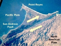
Point reyes in northern California, part of the Pacific
Plate,
separated from the North American Plate
by the the San Andreas Fault. |
The Pacific Plate moves NW along the San Andreas Fault relative to the North American Plate,
transporting with it terranes (fragments of continental material) and eventially piling
them up in the Gulf Of Alaska.
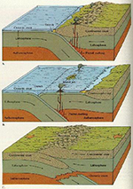
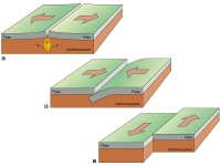
Convergent plate boundary; 3 scenarios
depending on the type of crust
involved.
From the University Of Ohio.
(Click to see a larger figure.) |
In the Gulf Of Alaska, the northeast boundary of the Pacific Plate makes a 90-degree
left turn and, almost just like that, it changes from a transform to a convergent plate
boundary. When two plates converge toward each other, one typically subducts underneath
the other. Which plate will subduct and which one will ride above depends mainly on the densities
of the material making up each plate. If plate convergence takes place between one plate
made up of continental material and another plate made up of oceanic material, the plate
made up of oceanic material will always be the one to subduct as it is made of denser rocks
like basalt, compared to less dense material like granite making up continental material.
If convergence takes place between two oceanic plates, each made up of basalt, the older
material will more likely subduct as it is cooler and therefore more dense than younger material,
which will tend to ride higher in the asthenosphere. When two plates made up of continental
material meet, such as the example of India and Asia, the result is a gigantic train wreck
resulting in the formation of gigantic mountains, because neither of the plates can easily
subduct as they are both composed of light continental material.
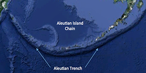
Aleutian Trench and island arc
(from Google Earth). |
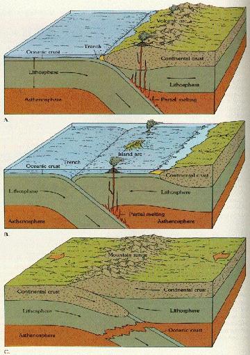
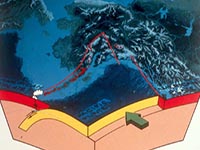
When ocean-ocean or ocean-continent subduction takes place, there are always two very obvious
features present: marine trenches and volcanic arcs. The actual subduction happens along
a long linear depression called a trenches, often deeper than the highest mountains seen
on dry land. The plate that subducts sinks deep into the mantle and gradually melts. The
resulting magma burns through the upper plate, creating a line of volcanoes called a volcanic
arc (or island arc, if happening in open sea).
Ocean-ocean subduction
(from PBS). |
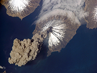
Eruption of Mt. Cleveland in 2006
(from Wikimedia Commons). |
Examples of ocean-ocean subduction are the Aleutians (left), the isthmus of Central America
from Nicaragua to Colombia, or the Indonesian island chain of Sumatra, Java, Bali, etc.
In the Aleutian example, oceanic crust of the Pacific plate is subducting beneath oceanic
crust of the North American Plate. The trench-arc system extends 3,000 km from the Kamchatka
Peninsula in the west to the Gulf of Alaska in the east.
In the Indonesian example, oceanic material of the Australian Plate subducts along the Sunda
Trench underneath the Sunda Plate, a small plate composed of mostly continental material.
A long of active volcanoes has developed forming the entire Indonesian archipelago, including
Sumatra, Java and Bali. The Krakatoa, located between west Java and Sumatra is one of these
volcanoes. On the Central American case, oceanic crust of the Cocos Plate converges with
the southern edge of the Caribbean Plate, subducts, and creates a volcanic island arc from
Nicaragua to western Panama. This area is dry land only because of tens of millions of years
of volcanic activity that spat out enough volcaniclastic material to form the isthmus of
Central America from Yucatan to Columbia. This dry land is not a continent, geologically speaking.
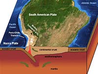
Ocean-continent subduction
(from Google Earth). |
Example of ocean-continent subduction are the western margin of South America, and the Pacific
Northwest of the U.S. In the South American example, oceanic crust of the Nazca Plate is
subducting beneath continental crust of the South American Plate. The Andes are the longest
continental mountain range in the world (about 7,000 km) long, and contain some of the highest
elevations outside of Asia. Geologically, they are the result of combined tectonic and volcanic
activity. Several successive orogenic cycles, plus island-arc type volcanism have combined
to form these mountains.
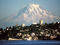
Mt. Rainier from the northwest
above the city of Tacoma
(from Wikimedia Commons). |
In the Pacific Northwest, oceanic crust of the Farallon Plate is subducting beneath
continental crust of the North American Plate. As in the South American example, the Rockies
are the result of pre-existing tectonic activity (older mountain building cycles), combined
later volcanic activity. Mt. Hood and Mt. St. Helens are examples of lava formed from the
melted material of the Farallon Plate that has been melted after it subducted into the
mantle.
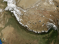
Continent-continent subduction
(from Google Earth). |
The best example of a continent-continent collision are the Himalayas, the highest mountain
range in the present-day world. Geographically, the mountain belt is 2400 km long stretching
across northern India. Geologically, the system is far wider. The Arakan Yoma highlands
in Myanmar, the Andaman and Nicobar Islands in the Bay of Bengal, plus the mountains in
Pakistan and Afghanistan were also formed in the same plate tectonic context.
Since the Late Cretaceous, about 70 million years ago, the north-moving Indian Plate
has been was moving northward at about 15 cm per year. This is extremely fast in terms of
geologic history! About 50 million years ago, this fast moving plate had completely closed
the Tethys Ocean and began to cause massive deformation when its continental crust began
to collide with the continental crust of the Asian Plate. As both plates are composed of
light continental crust, neither wants to subduct. Instead, the collision has created a
fold-and-thrust belt that forms the Tibetan Plateau and the Himalaya Mountains, and continues
to power deformation within the Asian Plate all from Kazakhstan all the way to Borneo.
Sedimentary and crystalline rocks bunched up like snow before a plow to form the Himalayas.
Transpressional deformation within the Asian Plate takes place in Central Asia forming the
Tien-Shan and Altai Mountains, the Lake Baikal depression, and the Tibet Plateau. Southeast
Asian tectonics is defined by "escape tectonics" where the entire area is being pushed aside
to the southeast as a result of the piston of India indenting the Asian Plate. This escape-tectonics
is being felt all the way to southeastern Borneo (c.f. Meratus Mountains). Meanwhile, the
Indian Plate is continuing its push north-east at 5 centimeters (2.0 in) per year, while
the Eurasian Plate is moving north at only 2 centimetres (0.79 in) per year.
This is causing the continued deformation of the Asian Plate, and the compression of the
Indian Plate at a rate of 4 millimetres (0.16 in) per year.
What Do Mineral Water, Alfred Wegener And Nazi Submarines Have In Common?
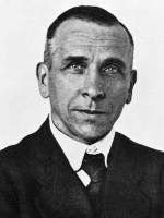
Alfred Wegener |
But how do we know that oceans spread, that new oceanic crust is being formed along mid-ocean
ridges, that plates collide, that oceanic crust is being consumed in subduction zones, that
giant mountains form when continental crust collides with continental crust?
The notion of continental drift was first intorfuced in 1912 Alfred Lothar Wegener. a German
polar researcher, geophysicist and meteorologist. He came with the idea that continents were
slowly drifting around the Earth. His hypothesis was controversial and not widely accepted
until the 1950s, when numerous discoveries such as palaeomagnetism provided strong support
for continental drift, and thereby a substantial basis for modern-day plate tectonics.
To be sure, Wegener did not get things quite right. His concept of continental drift was
that continents literally ploughed through the seafloor. The idea that the seafloor
itself moved like a conveyor belt, and carried the continents with it as it moved
away from a mid-ocean ridge, came later.

Bruce Heezen |
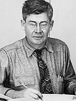
Maurice Ewing, founder of
The University Of Texas Institute
For Geophysics |
First was the discovery of the "Great Global Rift". It had been known since before WWII
that there existed chains of mountains within the Earth's oceans, but nobody could explain
their origin, purpose or function. In 1953, American physicists Maurice Ewing and Bruce Heezen,
studying the Mid-Atlantic Ridge, discovered that through the center of this underwater
mountain range ran a deep canyon. Because similar mid-ocean ridges had been known from
other Earth's oceans, they called this phenomenon the "Great Global Rift". This global rift
system appeared to divide the Earth's crust into plates, which were given the name "tectonic plates".
Building on this work was Harry Hess from Princeton University who, in 1960, advanced the
theory that oceanic crust moved laterally away from the long, volcanically active oceanic
ridges discovered by Ewing and Heezen.
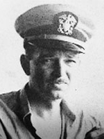
Harry Hess |
During WWII, Hess was a captain of a United States Navy attack transport ship. He made four
major combat landings, incuding Iwo Jima. His ship was equipped with a sonar for measuring
water depth during a landing. As a hobby, being a geologist, he used to to continuously record
seafloor profiles throughout his crossings of the Pacific Ocean using his ship's sonar
This unplanned wartime scientific surveying enabled Hess to collect ocean floor profiles
across the North Pacific Ocean.
With Ewing and Heezen's discovery in 1953 of the "Great Global Rift", a volcanic valley
running along the midocean ridges, Hess looked back at data he had collected during the war.
As a professor of geology at Princeton, in 1960 he hypothesized that sea-floor was being
created at the Rift where magma reached the surface, and that the seafloor as a whole was
moving laterally from the Rift, like two conveyor belts in a mirror fashion. His theory
that seafloor was being actively formed at the Rift and moving sideways, became
later known as "seafloor spreading".
Seafloor magnetic anomalies. |
In parallel with the work of Ewing, Heezen and Hess, other scientists were using other
wartime technologies to study the ocean floor. Beginning in the 1950s, scientists using
magnetometers adapted from airborne devices developed during World War II to detect submarines,
began recognizing odd magnetic variations across the bottom of world's oceans. As more and
more of the seafloor was mapped during the 1950s, these magnetic variations turned out not
to be random or isolated occurrences, but instead revealed recognizable patterns. When
these magnetic patterns were mapped over a wide region, the ocean floor showed a zebra-like
pattern: one stripe with normal polarity and the adjoining stripe reversed.

Lawrence Morley |
The link between the magnetic striping, geomagnetic reversals and seafloor spreading was
first correcly explained by the Canadian geophysicist Lawrence Morley, and by Britons
Fred Vine and Drummond Matthews. Morley was the director of the Geophysics Branch of the
Geological Survey of Canada during 1950–1969. In an attempt to explain the continental
drift theories previously proposed by Harry Hess and Alfred Wegner, Morley presented the
idea that there was a magnetic pattern of igneous rock on the ocean floor, which formed
as new magma rises to the surface in the middle of a mid-ocean ridge, accretes to the
existing seafloor and solidifies, the ferromagnetic minerals it contains record the polarity
of the Earth's magnetic field at the time of the magma cooling. Over time, as the polarity
of the Earth's magnetic field reverses, bands of seafloor with opposite polarity form parallel
to the mid-ocean ridge. The magnetic stripes closest to the ridge will be youngest, relative
to those being farther away. This was Morley's discovery. He used his evidence to explain
the hypothesis proposed previously by Alfred Wegner, a hypothesis that Wegener could not
solidly prove in his time.
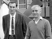
Fred Vine and Drummond Matthews |
Morley's research ran in parallel with the work of Fredrick Vine and Drummond Matthews,
Vine's PhD thesis at Cambridge was on "Magnetism in the Seafloor", supervised by Matthews.
Vine and Matthews showed that basalt created at a mid-ocean ridge records earth's current
magnetic field polarity (and strength), thus turning Hess's theoretical "conveyor belt"
into a "tape recorder". It was published before Morley's 1963 work and Morley felt his work
was therefore "unsuccessful". Nevertheless, work of these 3 geoscientists became known as
the "Vine–Matthews–Morley hypothesis".
Vine's work, with that of Drummond Matthews and Lawrence Morley helped put seafloor magnetic
anomalies, mid-ocean ridges and seafloor spreading into an integrated concept.
Specifically they supported Dietz's (Nature 1961) idea that sea floor spreading was occurring
at mid-ocean ridges.
earths_magnetic_field.jpg
plate_tectonics-midocean-ridge_and_magnetic_anomalies.jpg
The work in the 1950s and 1960s of Ewing, Heezen, Hess, Morley, Vine, Matthews and others
who laid the foundation for the new field of Plate Tectonics was one of the most fundamental
discoveries of all times. It revolutionized geology in a groundbreaking way and it advanced
our understanding of this planet. It built a framework for understanding how the Earth
evolved through geologic past; it provides a means for better earthquake prediction; it
serves as a frame of reference for understanding climate changes; and - last not least -
modern oil and gas exploration would be unthinkable without Plate Tectonics.
These scientists forever freed us from the dark days of believing in Geosynclines.
These people are to modern Earth science what Charles Darwin is to modern biology and anthropology.
Like Darwin before them, these scientists faced a considerable uphill battle in the face
of the establishment that, in their case, was neck deep in the outdated and surpassed concept
of Geosynclines. Plate Tectonics did not just replace Geosynclines as another favorite
"theory" of the time. It pushed modern Earth science giant leaps forward. By the 1980s,
it was no longer a theory but a proven and well-established fact, supported by ocean drilling,
radiometric dating, satellite data etc.
These scientists laid the foundation for a well understood, structured and quantitative view
of global geology, of how continents drift, how oceans and continents form, evolve and die.
That the discovery of Plate Tectonics happened during the Cold War in North America and Western
Europe, instead of some Communist-party-run institute in the Soviet Union, is a triumph of
free Western thought and creativity. Conversely, the fact that Geosynclines were still being
taught by many professors at universities behind the Iron Curtain in the 1980s, and Plate
Tectonics was mentioned merely as a "theory", is a damning statement about the the top-down
driven totalitarian regimes that had existed in Eastern Europe, controlled by the Soviet Union.
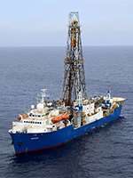
JOIDES Resolution drillship. |
While Communist-era universities in Eastern Europe were still stuck preaching Geosynclines,
no matter how backward it was,
the next obvious step after the development of the Vine–Matthews–Morley hypothesis was to
prove it and quantify it. This was accomplished by drilling wells into the seafloor
all over the world, taking samples and establishing ages of the seafloor magnetic anomalies
through radiometric dating. This global drilling campaign started in 1968 and continues to
present day. The United States National Science Foundation, plus funding from Australia,
Germany, France, Japan, the United Kingdom and China has paid for most of the drilling
program, and various universities, including the University Of Texas Institute For Geophysics,
ODP, DSDP and IODP wells drilled between 1968
and 2014. (Click to see a larger figure.) |
executed it. First was the Deep Sea Drilling Project (DSDP), followed by the Ocean Drilling
Project (ODP), and the Integrated Ocean Drilling Program (IODP). Between 1968 and 2014,
using the drillships Glomar Challenger and Joides Resolution, these programs drilled several
hundred strategically positioned wells throughout the world's oceans to date the age of
the seafloor.
Simplified plate-tectonic animation showing the breakup of Panguea,
opening of the Atlantic Ocean, closure of the Tethys Ocean,
and the collission of India with Asia. |
Once the ages of the magnetic stripes on the ocean floor became established
through radiometric dating, it became possible to start building plate-tectonic models by
playing the ocean-floor spreading backwards and reassembling the continents back to whey
they were at the time of the Pangea breakup.
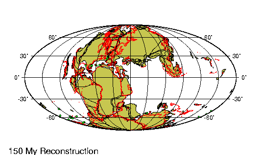
Plate reconstruction from the Plates Project
of the Tethys Ocean during the Cretaceous
(150 millions years before present). |
This led to the development of a number of plate reconstruction projects that have been
running since the 1970s. They are using seafloor magnetic anomalies and other geologic data
to restore plate motions throughout the geologic history of the Earth, going as far back as
possible. The three principal projects are the Plates projects at the University
of Texas At Austin; the Paleomap Project developed at the University Of Texas At Arlington;
and Colorado Plateau Geosystems created at Northern Airzona University.
The outputs of these projects are used in academia for further research (geology, climatology),
in predicting earthwuake hazards, and in the petroleum industry to help find more oil and gas.
To the lay public, they offer a fascinating window into the history of our planet,
helping us understand where the world came from and why it looks today the way it does.
One does not have to be a geologist to understand or appreciate.
Sources:
- http://jameskennedymonash.wordpress.com/2013/12/24/holmes-or-tufte-mineral-water-composition-chart/
- http://www.dailymail.co.uk/news/article-2706380/How-sparkling-mineral-water-11-times-SALT-tap-water.html
back to Radim and Lisa's Well-Travelled Cookbook | email us
Last updated: December 15, 2014
Certain images from Wikimedia Commons, used under the terms of the GNU Free Documentation License.

|