   |
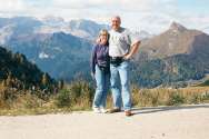
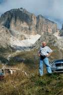
Province of Veneto, Italy
|
|
|
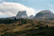
There is no lens but the human eye that can catch and truly comprehend
the total grandeur of the Dolomites. Imagine towering pinkish-white dolomite
peaks set against the background of dark blue skies and deep green forests
and meadows in the foreground! Although not
nearly as high as the Colorado or New Mexico Rockies, these mountains take
on a much more mountainous appearance. The mountains around Vail or Santa
Fe are rounded and forrested almost all the way to the top. The Dolomites,
on the other hand, are steep and wild, romantic and majestic, leaving the
treeline far below in their reach for the sky.
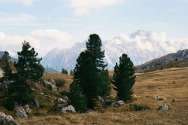
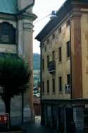
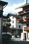
The lattitude of this region is roughly comparable to that of the Canadian province of Alberta. That means that the treeline is at approximately 5000 feet, as opposed to the usual 10000 feet in Colorado or New Mexico. This alone will give any mountain higher than 6000 feet a much more alpine look than a 12000-foot peak in Colorado. Yet, despite the rugged alpine scenery, the Dolomites are not an untamed wilderness one expects from the Rockies. Nor does one have the feeling of wide open spaces and remoteness of the American West. People actually live in these mountains. There are mountain lodges on every peak with cable cars delivering supplies to them, hiking and mountain bike trail seemingly everywhere. Small villages and towns dot the mountainsides. Some are nested in the deep valleys, while others are perched on cliffs and mountains like drawings from a fantasy storybook. Gothic, Renaissance and Baroque churches and town houses are nested among towering mountain peaks. It is precisely the combination of old architecture set against the background of the Alps that makes this region so beautiful in its own way - and so different from Colorado. During the summer dramatic sunsets form silhouettes of gigantic formations of earth and stone, the soft green of the Ampezzo Valley lying snugly within these finely etched mountains. Photographers must surely experience intense emotions as they try to capture this ever-shifting, surreal scene on film. The colors of the landscape change constantly as the sun moves across the sky. Blue lakes reflect the hard-edged peaks; delicate green meadows, surrounded by unforgiving jagged rock formations, are ablaze with wildflowers. Grand hotels built in the 1920s and 30s lend an elegant touch to Cortina. The hills above are dotted with the charming country chalets of important Italian families who come to Cortina for winter sports and August holiday. Cortina, at 3970ft (1210m), is surrounded by many peaks over 10,500ft (3200m). Visitors arriving in Cortina for the first time are stunned by the magnificent sight of the surrounding Dolomites - the mountain groups of Tofana, Pomagagnon, Cristallo, Sorapis and Croda da Lago - and the Boite River running through the city. 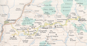
The way from Bolzano to Cortina takes us via a mountain road called the Grande Strada delle Dolomiti. To call this drive "scenic" is a at best an understatement - the experience is simply breathtaking! At the beginning there is the wide-open Fassa Valley with a nice wide highway running through the towns of Moena, Vigo di Fassa, Mazzin, Campitello and Canazei. East of Canazei (1460m, 4788ft) the road narrows and becomes a twisting paved mountain path. The Climb starts. First, a series of 8 sharp switchback curves followed by a long northward straight leads to the village of Lupo Bianco at 1715m (5625ft) - we have reached an elevation slightly higher than that of Albuquerque. 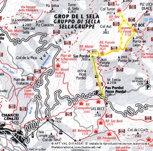 Next, eight more sharp switchbacks followed by a long southward uphill
straight bring the road to at elevation of 1926m (6317ft) at the village
of Pecol. At this point "only" 16 more switchbacks remain to the top of
the pass. Try to avoid meeting a downward-heading tour bus head-on at the
apex of a curve. About halfway up we cross the 2000m mark (6560ft) and
pass the mountain chalet of Ciampolin, the elevation of which is roughly
comparable to that of Santa Fe. After climbing another 200 vertical meters,
we arrive on top of Passo Pordoi
(Pordoi Pass). At 2244m (7360ft) the pass is nested between the 2534 (8311ft) Sas
Bece to the south and the 2950m (9676ft) Sas Pordoi to the north.
In comparison to these mountains, the top of Sandia Peak is at 10378ft (3164m) - the only summit
in this area higher than that is the Marmolada to the south, reaching
10965ft (3342m). The relatively low elevation of this terrain has one important advantage:
hiking is relatively easy because there is air here...
Next, eight more sharp switchbacks followed by a long southward uphill
straight bring the road to at elevation of 1926m (6317ft) at the village
of Pecol. At this point "only" 16 more switchbacks remain to the top of
the pass. Try to avoid meeting a downward-heading tour bus head-on at the
apex of a curve. About halfway up we cross the 2000m mark (6560ft) and
pass the mountain chalet of Ciampolin, the elevation of which is roughly
comparable to that of Santa Fe. After climbing another 200 vertical meters,
we arrive on top of Passo Pordoi
(Pordoi Pass). At 2244m (7360ft) the pass is nested between the 2534 (8311ft) Sas
Bece to the south and the 2950m (9676ft) Sas Pordoi to the north.
In comparison to these mountains, the top of Sandia Peak is at 10378ft (3164m) - the only summit
in this area higher than that is the Marmolada to the south, reaching
10965ft (3342m). The relatively low elevation of this terrain has one important advantage:
hiking is relatively easy because there is air here...
See also this panoramic view of the Fasa Valley and road leading up to Pas Pordoi. From Passo Pordoi the road descends sharply eastward through numerous steep sharp switchbacks into a wide valley on the east flank of The road turns northwestward and starts to rise again toward the towns of Andraz (1414m, 4637ft) and Cernaddi. The road starts climbing in earnest toward Passo Falzarego, teh second mountain pass just before Cortina. The climb starts with a series of switchbacks carved into the mountainside and supported by aquaduct-like butresses likely built in the early 1900s as part of Austrian military fortifications. To the left, carved into the side of the 2177m (7140ft) Sasso di Stria, ruins of these World War I fortifications and galleries are visible. Several times one notices a narrow tunnel entrance dug into the mountain. The road turns east and finally reaches "Passo Falzarego (Falzarego Pass) at 2105m (6904ft) - again roughly the elevation of Santa Fe. Passo Falzarego is located between the beathtaking peaks of Cinque Torri (Five Towers, 2361m, 7744ft) and the Tofana di Rozes massif (3225m, 10578ft). Yet, despite is majestic and rugged look, the Tofana is "only" about as high as the Sandia Peak above Albuquerque, and nowhere as tall as the 13161ft (4011m) Wheeler Peak above Taos. The drive continues eastward and gently downward to the city of Cortina. In all, the drive from Bolzano to Cortina is 109km (67 miles) and would take 3-4 hours if you did not stop. Hats must go off to the Italian, German and Austrian bus drivers who navigate the tight switchbacks below Passo Pordoi. Even more hats go off to those folks who race on this road during the Giro d'Italia... Sources: Cortina official website, Il Gioscopio, Alpineskimaps.com, La Grande Guerra |
Continue your virtual visit on these websites:
Cortina live
camera views
360° panorama
view from Sass Pordoi
Private collection
of ski pictures from the Passo Pordoi area
Passo
Falzarego guide by Dolomiti.org
Cortina
official website
Nice 3D relief map covering Austrian Alps and the Dolomites from Innsbruck to Venice
Passo Pordoi area hiking topo map
Canazei area hiking topo map
Radio
Cortina live in streaming audio
A gallery of antique lithographs from Rareprints.de
Photographs (c) 2001 Radim and Lisa Kolarsky
Last updated October 28, 2001